Day 7, June 26th we decided to venture into Mesa Verde National Park before leaving the area. It was very foggy and this made for a somewhat diminished experience. I imagine the scenery on either side of the road would have been impressive based on what I could see. We did manage to find one of the view points for the Anasazi Indian cliff dwellings, truly remarkable. Nathan says it was one of his favourite parts of the trip.
Based on the advice from the clerk at the motel last night we have altered our route slightly and we headed southwest through a spot called The Four Corners where all at once you are in Colorado, New Mexico, Utah and Arizona. We filled up with gas in Teec Nos Pas, Arizona before heading west on 160, again different terrain, unique rock formations in form and colour. We turned off 160 and headed north on 191 to 163. Now I should mention that as far as the weather goes we had been blessed to this point. Apart from the few hours the morning we left and the little bit around Telluride it had been very good. Well you guessed it, that was about to change. As we rode along highway 191 approaching the junction with hwy 163, I noted how the sky off the left side of the highway was looking particularly, hummm, uninviting. We turned west on 163 and stopped at a high spot in the highway before descending down into the low ground. This gave us a front row seat to approaching storm and it became abundantly clear that it wasn’t going to miss us so on went the rain gear and on we went. It was an interesting experience. Being able to see the storm come from so far off across such open ground was amazing. Now I have seen storms blow in before but I could see this wall of red rain coming toward us only to realize this was the wind pushing a wall of the red coloured soil ahead of the wall of rain…and then the wind came. I personally have never encountered a wind that threw me around like this one did. I suspect that it was a combination of the way the weight on the bike was distributed and the direction and gusty nature of the wind. I pulled over on an area of the highway where they had blasted through some rock to make way for the road and it provided some shelter for a minute. The storm passed quickly and we were off again.
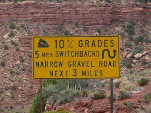
We turned north on hwy 261 and stopped to take off our rain gear. We met two other riders at this spot consulting their map and wondering if they should continue. They decided to forge on and left travelling north. We stowed our rain gear and headed off after them. A short distance later we found them pulled over at the side of the road no doubt contemplating turning around, for in the distance was a sheer rock cliff that gave the appearance that the road we were on ended. Well technically it did, a short time later there was a sign warning of the rather steep, unmaintained gravel road ahead. The other riders turned back, mistake, big mistake, huge.
We carried on and this became one of my favorite parts of the trip. We climbed up this aforementioned sheer rock face by a series of switchbacks. Lots of opportunity to pull over and take photos of the Valley of the Gods, spectacular, a word I find myself using a lot on this trip.
We eventually connected with highway 95 and turned west. Unfortunately it is impossible to see everything on any trip and this was one of those moments. As we headed west on 95 we passed by the entrance to Natural Bridges National Monument and kept on riding. Something for the next trip perhaps. It was getting on in the day and dad was running low on gas. Checking my trusty GPS I found that we were between a rock and a hard place as far as gas stations go. We carried on very conservatively trying to make the gas last. As you’ll recall I made a comment at the outset about the limitations of a GPS, thank goodness they can be wrong. As we rounded another high monument revealing another vicious looking thunder storm moving toward us we came upon the most glorious of signs, Hite National Park access to Lake Powell and fuel. We got gassed up and took shelter in the general store as the storm hit. We learned that Lake Powell at this location wasn’t quite the lake it used to be with water levels considerably lower in the past several years. The once thriving marina was now above the water line, not a highly sought after quality for a marina I imagine.
The storm passed and we were on our way passing briefly through Canyonlands National Recreation Area, another spot for closer inspection on a future trip. We stopped in Hanksville, Utah for the night. Nice private cabin style accommodations at the west end of town on hwy 24.
Day 8, June 27th A nice morning through some open space and then into a canyon which had an oasis sort of feel to it. We stopped at a rest stop and took a little hike and found out some interesting information about this area. Along the cliff walls of the canyon were petroglyphs left by ancient Indian tribes.
Much later the area was settled by Mormon’s who brought with them advanced irrigation systems that permitted them to grow and sustain fruit trees. Moving on just a short distance further we found the entrance to the Capitol Reef National Park.
We decided to take the 20 mile round trip into the park. This was another one of those “it can’t possibly get more beautiful than this” moments. When the paved road ended deep in the park we decided to press on along the dirt road for a short distance. There was a sign at this point that warned about venturing any further under threat of flash floods. The road would definitely become a river when it was raining; today however was bright and sunny as far as we could see and the road was drying. It led into a narrow high walled canyon that was reminiscent of something from an Indiana Jones movie. Not knowing how far this went on we turned around and videotaped the entire ride out on my GoPro helmet camera.
Near Torrey we turned south on hwy 12 which eventually took us through the Dixie National Forrest and a number of changes in elevation. We stopped at a couple scenic lookouts and took an opportunity once again to take some pictures.
Coming out of the Dixie National Forrest into the Grand Staircase-Escalante National Monument was incredible. Once again I was astounded by how quickly the geography changes in just the matter of a few kilometers. This area is difficult to describe and really must be experienced.

Grand Staircase Escalante
The same could be said for the Bryce Canyon National Park which was our next stop. We spent an hour or so at Bryce Canyon, hiking around and taking some pictures. I really don’t know how to describe the view from some of the spots we stopped within the park. One regret I learned later from a friend that we could have actually gone down inside all the spires which some have described as “a cave without a ceiling“ or “a forest of stone”. No matter how you choose to describe it you will fall well short of doing it justice.
Leaving the park we headed west on 12 and south on 89 finally coming to rest for the night in Mt. Carmel Junction, a very unique spot indeed with an equally interesting history as a Mormon settlement.
Day 9, June 28th would begin with a trip through yet another of Utah’s magnificent parks, Zion. Quite possibly the most interesting so far and as I would learn later for all the beauty we saw we missed a lot. As highway 9 weaves through Zion it passes through tunnels and a series of switchbacks as you descend to the floor of the park. I would state without hesitation if there was only one spot on our trip that I could go back and spend more time Zion would be that spot. I have spoken to people since our trip that have spent days just camping and hiking around this park and it is easy to see why.
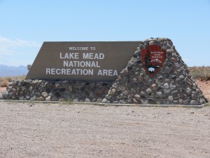
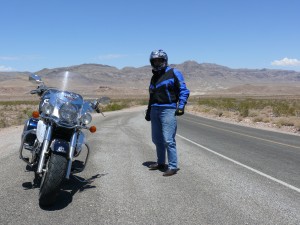
After leaving Zion we connected to Interstate 5 southwest toward Vegas and as the day wore on the temperature started to rise. There were actually a couple of sections of Interstate 5 that were very twisty and scenic. We had been contemplating taking Hwy 169 around Lake Mead and almost didn’t after we were speaking with a couple of guys from Vegas who advised it was OK but the roads were rough. We decided to take it anyway and Hwy 169 was fine and actually quite twisty and fun, oh and hot, incredibly hot as the temperature gauge on dad’s bike peaked at 124 degrees. The small, stick on, digital gauge I had purchased ceased to function. Despite the huge volume of fluid I had been taking in I was starting to feel dehydrated. I was riding with the helmet visor down because of the heat and it was becoming abundantly clear that at the end of this trip I would be throwing it out as it was developing a rather unpleasant odour. I cannot understate this, stop every hour and drink, lots!
We got to Hwy 93 and the traffic was backed up past this point back toward Vegas, congested with everyone wanting to go to Hoover Dam.
I asked Nathan if he wanted to see Hoover Dam or find a nice cool hotel, “hotel” was the answer so….we of course went to Hoover Dam. Reflecting back I’m not sure why I gave him the choice, when I knew in my mind, we traveled this far, we were going to see the damn dam.
It was worth the 45 minutes it took to get the last couple of miles. I have seen a Discovery Channel documentary on the construction of the dam and it was quite an amazing feat. Very interesting to see the progress of the new bridge being built which was the subject of another Discovery Channel program, “Megabuilders”.
Looking east of the dam down on Lake Mead it is difficult to say but the level of the lake appears to be 40’ or more lower than it has been in the past based on the colour of the rock along the shore line.
We rode into Vegas and stopped for an ice cold pop in an air conditioned Burger King. I wondered if they would let us sleep on the floor in a corner. I promise I won’t take up much space. Maybe not all night would be an unreasonable request but perhaps just until the sun goes down and the temperature returns to a more humane level.
Alas we moved on but a short distance later sought refuge in the Silverton Hotel and Casino for the evening. A couple hours later, once settled in and with a swim and couple of cool beers, balance was restored to the universe. A short reprieve because tomorrow, Death Valley, so early to bed for an early start, in some sort of feeble attempt to beat the heat. Time will tell if it works.
ROUTE MAP DAYS 7 TO 9


